M/S Estonia
An accident that affected many.
The safety investigation authorities of Estonia and Sweden, in collaboration with Stockholm University and Ocean Discovery AB, among others, have carried out investigations of the wreck of the passenger ship Estonia and the bottom conditions around the ship. Here we report on the photo documentation that was carried out during the summer of 2022, which resulted in approximately 45,000 photographs.
THERE WAS NEW INFORMATION THAT NEEDED TO BE EXAMINED.
The passenger ship Estonia sank on September 28, 1994 during a voyage from Tallinn to Stockholm.

Of the 989 people on board, 852 people died. In accordance with an agreement between the Prime Ministers of Estonia, Finland and Sweden, a temporary Joint Accident Investigation Commission was formed to investigate the accident (JAIC). A final report was published in December 1997 and the JAIC was subsequently disbanded.
On September 28, 2020, footage was published showing a previously unknown hole in the ship's starboard side. The Estonian Safety Investigation Bureau therefore initiated a preliminary assessment of the new information and requested assistance from the corresponding authorities in Finland and Sweden.
The Safety Investigation Authority of Finland and the Swedish Accident Investigation Authority decided to assist the Estonian authority. The purpose of the preliminary assessment is to consider whether the new information gives reason to revise the conclusions drawn in the 1997 report, whether new investigative measures should be taken and, if so, what.
For further information on the work on the preliminary assessment, see here.
A CHALLENGING INVESTIGATION.
The ship lies on the bottom of the Baltic Sea approximately 20 nautical miles from the nearest land at a depth of 70-85 meters.
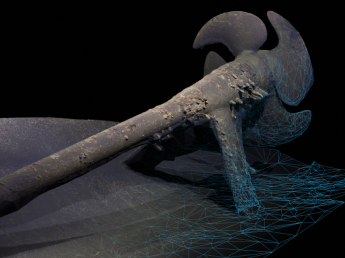
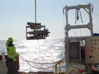
Modern photogrammetry technology makes it possible to create a detailed model of the wreck without having to send divers down. By sending down a diving robot (ROV) that takes thousands of high-resolution still images of the hull from the outside, a detailed 3D model of the wreck can then be created.
SHK hired Ocean Discovery, specialists in ROV inspections and used to carrying out advanced investigations of both environmentally hazardous wrecks and archaeological wrecks with photogrammetry.
– You can see every hole in the wreck, every clam, down to millimeter level. It is incredibly detailed documentation method, says Ingemar Lundgren which uses the new technology.
A 3D model of the wreck leaves very little to be done the imagination, says Lundgren, who is also experienced in technology divers and conduct this kind of research on commissioned by, among other things, the Maritime and Water Authority.
– We examined every square meter of the wreck so that nothing is missed. It is possible to measure damage and holes with great precision, he says. 3D scanning of wrecks is one method that has been possible for only a few years.
– This was a survey that was done externally. We didn't go into cabins and film remains. The risk of find remains was very small. I have examined many wrecks where there are deceased, but I never have encountered anyone in this type of investigation.
FIND ANSWERS TO MORE QUESTIONS.
If you can't find the answers below, contact us and we'll help you along the way. Do you have questions concerning our investigations that you can't find answers to? Or views? Contact us below.